DISCLOSE researchers are planning an autumn research cruise, and preparations are in full swing. Next week we’ll set sail to revisit the Bruine Bank and map the area in detail. We will report to you straight from the RV Pelagia. By following this blog, you can see how we work, what we find, and how we use our data to predict life on the sea floor. With this first post, we give you a bit of an introduction on our planned work.
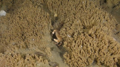
The goal of the DISCLOSE project is to understand the communities living on the bottom of the North Sea. The Bruine Bank is a shallow sandbank in the North Sea flanked by two deeper troughs. The deeper and shallower areas attract different types of life. Therefore, it is quite interesting to study. We already know we might find majestic tubeworm reefs formed by the organism Sabellaria spinulosa (Figure 1).
(Image credit: © OCEANA).
To determine exactly where we want to go, we first have to make a detailed map of the sea floor. We will do this using acoustic techniques like side scan sonar and the multibeam echosounder. To use this technique, we have to sail over the research area in parallel lines. We will send out sound waves as we go, and count how long the waves take to get back to the ship. Also, we measure backscatter. Backscatter is the change in intensity of the soundwaves due to complex interactions with the seafloor. This gives us detailed information on the depth and the type of sediment around the ship.
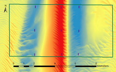
Then, we will collect data from three so-called “transects” oriented from east to west in the study area. A transect is basically a straight line through a study area where you collect data. Measuring along a transect is a useful method if you want to detect if communities change along a gradient. As you can see from the map (Figure 2), this means we will study different areas: the deeper troughs (blue) and the sandbank (red). In each area, we will film the sea floor, collect a big bucket of sand, and take a sediment profile image. The latter is a picture of what the sand looks like below the surface.
We will film at several locations along the transect while sailing in a northern or southern direction. This ensures that the depth will be constant throughout the video. Each video will cover about 200 meters of sea floor. The videos are watched to identify the life crawling about.
The buckets of sand are also called ‘box cores’, and these will preferably be taken at locations we’ve already observed on video. This is because these areas have been ‘ground-truthed’. This means we have already directly observed the sea floor, and can therefore better interpret the data from the box core. The box cores are sieved through to find all the tiny organisms living inside the sediment.
To understand the chemistry of the sediment, we analyse the chemicals from a separate box core. We also look at sediment profile images. A sediment profile image is like digging a hole at the beach, and then looking at the sand sideways. That way you can see if the sand changes colour or if the grains get coarser or finer with depth.
We then compare the life and habitats in all three transects. Back in the office, we will use computer techniques to predict life in each transect. For example, if you tell the computer what the first and second transect look like, it will predict how the third transect may look.
Of course, we know what the third transect looks like, so we can check it against the prediction.
We’ll set sail on Thursday October 26th and we want to write a blog every two to three days. In these blogs we will show you exactly how we work to collect this data and what we find in our samples. We hope you join us at sea!


