Seafloor habitats can be predicted by environmental conditions. Bathymetry and sediment type are generally used as first determinants of seafloor habitat distribution and as such, of the associated macrofauna communities. However, local physical and chemical conditions and man-made disturbances also determine the distribution of habitats. International projects have led to substantial knowledge on the spatial distribution of all these conditions at the large scale (square kilometers) and translated them to large-scale habitat maps. On a small-scale (tens of square meters), however, the effects of aforementioned conditions on the establishment of seafloor habitats are poorly studied. That is why this sub-project wants to gain insight in the distribution of the different seafloor habitats on a much smaller scale of some hundred square meters.
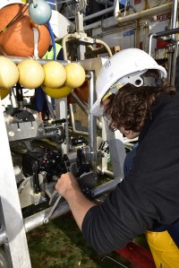
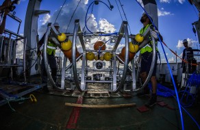
Next to existing data, this sub-project will use newly-collected underwater video footage to verify the expected seafloor habitats and the associated macrofauna communities. For this end, a towed video system is developed, after a system deployed by the University of Plymouth. Underwater video transects are chosen to represent sets of similar environmental conditions under varying anthropogenic disturbance levels. Based on this analysis and verification, areas with high potential for the development of vulnerable habitats and communities can be are identified.
To work at the desired small-scale, the positioning of the underwater video transects in relation to the prevailing environmental conditions should be as precise as possible. This accuracy is ensured by incorporating highly-detailed multibeam maps produced in the first sub-project. Video footage cannot reveal all features and species. It will only provide information on the distribution and abundance details of features and species living on top of the seafloor (epifauna). Species, such as worms and bivalves (infauna), which are important for seafloor habitats and associated communities as well, will be missed. Bottom samples taken in the third sub-project will ensure that our analysis of the seafloor community in relation to habitat is as complete as possible.
In the end, this sub-project will result in high-resolution maps of the DCS displaying seafloor habitats, as classified by environmental conditions and anthropogenic disturbances, including exact predictions of vulnerable habitat distribution. Additionally, vulnerable habitats which have the potential to recover when subject to reduced anthropogenic disturbance are identified and displayed. These maps will be made available for the general public in an interactive web application